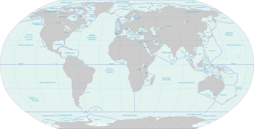
Southern Ocean
Southernmost ocean encircling Antarctica, defined by circulation and latitude.
The Southern Ocean, sometimes called the Antarctic Ocean, is the world’s southernmost body of water, generally defined as the waters south of the 60th parallel that encircle Antarctica. It covers 21,960,000 square kilometers (8,480,000 square miles), making it the second smallest of the five main oceans—larger than the Arctic but smaller than the Pacific, Atlantic, and Indian. Its deepest point was measured in early February 2019 by the Five Deeps Expedition using multibeam sonar, reaching 7,434 meters (24,390 feet) at coordinates 60° 28' 46"S, 025° 32' 32"W. Expedition leader Victor Vescovo, who piloted the submersible DSV *Limiting Factor* to the bottom on February 3, 2019, has proposed naming this spot the "Factorian Deep."
For centuries, geographers disagreed on whether the Southern Ocean should be defined by the seasonally shifting Antarctic Convergence—where cold Antarctic waters meet warmer Subantarctic waters—or whether its waters should simply be considered the southern extensions of the Pacific, Atlantic, and Indian Oceans. In 2000, the International Hydrographic Organization (IHO) settled the debate after recognizing the importance of the Southern Ocean overturning circulation, and now defines the ocean as the waters south of that circulation’s northern limit. This overturning circulation forms the second half of the global thermohaline circulation, after the Atlantic meridional overturning circulation (AMOC). Like AMOC, it has been heavily affected by climate change, increasing ocean stratification and potentially slowing or even collapsing past a tipping point. Such a collapse would harm global weather and marine ecosystems over centuries, and ongoing warming is already altering those ecosystems.
**Definition and term use**
The IHO’s precursor, the International Hydrographic Bureau, first agreed on ocean borders and names at a conference on July 24, 1919, publishing them in *Limits of Oceans and Seas* in 1928. Since then, the Southern Ocean’s limits have moved progressively southward; after 1953, it was omitted from the official publication, leaving local hydrographic offices to set their own boundaries. The IHO included the ocean in its 2000 revisions, defining it as waters south of the 60th parallel, but this has not been formally adopted due to unresolved disputes, such as the naming of the Sea of Japan. The 2000 definition was circulated as a draft in 2002 and is used by some IHO members and organizations like the CIA World Factbook and Merriam-Webster. The Australian government considers the Southern Ocean to lie immediately south of Australia. The National Geographic Society officially recognized the ocean in June 2021; before that, it showed the Pacific, Atlantic, and Indian Oceans extending to Antarctica on its maps. Map publishers Hema Maps and GeoNova use the term on their maps.
**Pre-20th century**
"Southern Ocean" was once an obsolete name for the Pacific Ocean or South Pacific, coined by Spanish explorer Vasco Núñez de Balboa, the first European to see the Pacific from Panama. "South Seas" is a less archaic synonym. A 1745 British Act of Parliament offered a prize for discovering a Northwest Passage to "the Western and Southern Ocean of America." Authors using "Southern Ocean" for waters around the unknown southern polar region used varying limits. James Cook’s second voyage account implies New Caledonia borders it. Peacock’s 1795 *Geographical Dictionary* placed it "to the southward of America and Africa"; John Payne in 1796 set the northern limit at 40 degrees; the 1827 *Edinburgh Gazetteer* used 50 degrees. *The Family Magazine* in 1835 split the "Great Southern Ocean" into the "Southern Ocean" and the "Antarctick [sic] Ocean" along the Antarctic Circle, with the Southern Ocean’s northern limit connecting Cape Horn, the Cape of Good Hope, Van Diemen’s Land, and southern New Zealand. The United Kingdom’s South Australia Act 1834 described the waters forming the southern limit of the new province as "the Southern Ocean." The Colony of Victoria’s Legislative Council Act 1881 delimited part of Bairnsdale as "along the New South Wales boundary to the Southern ocean."
**1928 delineation**
In the 1928 first edition of *Limits of Oceans and Seas*, the Southern Ocean was defined by land boundaries: Antarctica to the south, and South America, Africa, Australia, and Broughton Island, New Zealand to the north. The detailed limits ran from Cape Horn in Chile east to Cape Agulhas in Africa, then east to the southern coast of mainland Australia to Cape Leeuwin, Western Australia. From there, the limit followed the coast east to Cape Otway, Victoria, then south across Bass Strait to Cape Wickham on King Island, along the island’s west coast, and then the remainder of the boundary.
- size
- 21,960,000 km² (8,480,000 mi²)
- rank
- second-smallest of five principal oceanic divisions
- maximum_depth
- 7,434 metres (24,390 ft)
- deepest_point
- Factorian Deep at 60° 28' 46"S, 025° 32' 32"W
- deepest_point_discovered_by
- Five Deeps Expedition, February 2019
- northern_limit_definition
- south of 60° S latitude (IHO 2000 draft) or seasonally fluctuating Antarctic Con
Lore & Background
The Southern Ocean was first delineated by land-based limits in the 1928 first edition of Limits of Oceans and Seas, extending from Antarctica northward to South America, Africa, Australia, and Broughton Island, New Zealand. In the 1937 second edition, its northern limits were moved southward to latitudes 40°S between Cape Agulhas in Africa and Cape Leeuwin in Western Australia, and to latitude 55°S between Auckland Island of New Zealand and Cape Horn in South America. However, the 1953 third edition omitted the Southern Ocean entirely, with a note stating that 'the majority of opinions received since the issue of the 2nd Edition in 1937 are to the effect that there exists no real justification for applying the term Ocean to this body of water, the northern limits of which are difficult to lay down owing to their seasonal change.' The Atlantic, Pacific, and Indian Oceans were therefore extended south to the Antarctic Continent. The IHO readdressed the question in a survey in 2000, where 28 of 68 member nations responded, and all except Argentina agreed to redefine the ocean. The proposal for the name Southern Ocean won 18 votes, beating the alternative Antarctic Ocean. Half of the votes supported a definition at the 60th parallel south, with other votes for definitions as far north as the 35th parallel south. The National Geographic Society recognized the ocean officially in June 2021.
Reader's Guide
The Southern Ocean's significance lies in its role in global climate and ocean circulation. Its overturning circulation makes up the second half of the global thermohaline circulation, after the better known Atlantic meridional overturning circulation (AMOC). Much like AMOC, it has been substantially affected by climate change, in ways that have increased ocean stratification, and which may also result in the circulation substantially slowing or even passing a tipping point and collapsing outright. The latter would have adverse impacts on global weather and the function of marine ecosystems here, unfolding over centuries. The ongoing warming is already changing marine ecosystems here. The ocean's maximum depth was surveyed by the Five Deeps Expedition in early February 2019, whose multibeam sonar team identified the deepest point at 60° 28' 46"S, 025° 32' 32"W, with a depth of 7,434 metres (24,390 ft). Expedition leader Victor Vescovo proposed naming this deepest point the 'Factorian Deep', based on the name of the crewed submersible DSV Limiting Factor, in which he successfully visited the bottom for the first time on February 3, 2019.
Did You Know?
- The Southern Ocean was omitted from the IHO's 1953 third edition of Limits of Oceans and Seas, with a note stating most opinions held there was no real justification for applying the term 'Ocean' to this body of water.
- The deepest point, Factorian Deep, was visited for the first time on February 3, 2019, by Victor Vescovo in the crewed submersible DSV Limiting Factor.
- In the IHO's 2000 survey, 28 of 68 member nations responded, and all except Argentina agreed to redefine the Southern Ocean.
- The Southern Ocean overturning circulation makes up the second half of the global thermohaline circulation, after the Atlantic meridional overturning circulation (AMOC).
- The National Geographic Society officially recognized the Southern Ocean in June 2021; prior to this, it depicted it in a different typeface on its maps.
Frequently Asked Questions
Who is the Southern Ocean?
The Southern Ocean is the circumpolar body of water that wraps entirely around Antarctica, typically defined as all waters south of 60° S latitude. It is the second-smallest of the five principal oceanic divisions, covering roughly 21.96 million square kilometres.
What makes the Southern Ocean unique compared to the other four oceans?
Unlike the other divisions, it has no land borders and is instead delineated by the seasonally shifting Antarctic Convergence and its surrounding circulation. Its maximum depth of 7,434 metres, found at the Factorian Deep, was first confirmed by the Five Deeps Expedition in February 2019.
Where is the deepest point in the Southern Ocean?
The Factorian Deep sits at approximately 60° 29' S, 25° 33' W and plunges to 7,434 metres (24,390 ft) below the surface. It was identified and sounded by the Five Deeps Expedition in early 2019.
Why has the Southern Ocean's boundary been so controversial?
Because it encircles a continent with no fixed coastline, geographers and the International Hydrographic Organization have long debated whether its northern edge should follow the 60° S line or the fluctuating Antarctic Convergence. This unresolved definition has kept the ocean's exact size and scope in flux for decades.
Why is the Southern Ocean important to global oceanography?
As the only ocean defined by a current system rather than continental boundaries, it acts as a critical conveyor belt linking the Atlantic, Pacific, and Indian Oceans. Its relatively modest area belies a disproportionate influence on worldwide climate regulation and marine biodiversity.
More in Seas And Oceans 1-24
Related in Seas And Oceans
Links follow this subject's own source article.
Spotted an error? Know more?
This is a living reference — every entry is fact-audited, and reader corrections feed straight into our audit queue. Suggest an edit · See this site's audit record